EUDR Geolocation Data & Supply Chain Mapping Guide
The EU Deforestation Regulation (EUDR) is set to reshape how commodities like coffee and cocoa are traded within the European Union. Starting at the end of 2025, companies will need to prove that the products they import are not linked to deforestation after December 31, 2020.
At Daarnhouwer, this regulation aligns with our long-standing commitment to transparency, quality, and sustainable sourcing. We see it not as a burden, but as an opportunity to strengthen our relationships with suppliers and future-proof our supply chains.
From Trust to Traceability: A New Level of Detail
For many years, our sourcing model has relied on deep, trust-based relationships with smallholder farmers, cooperatives, and exporters. Through certifications, field visits, and local knowledge, we’ve been able to manage deforestation risks with care and responsibility.
However, the EUDR requires a higher level of traceability. We must now provide precise location data, clear plot boundaries, and legal documentation that meets regulatory scrutiny. This means we need to know exactly where every shipment’s coffee or cocoa was grown. We must also show no deforestation has occurred on or near those lands since 2020.
What Suppliers Must Provide: Geolocation Data for Each Plot
To comply with EUDR, Daarnhouwer must submit geolocation data for every plot where coffee or cocoa grows. We ask our suppliers to provide this data following the EU’s technical requirements.
What Is Geolocation Data?
Geolocation data uses GPS coordinates to pinpoint a farm plot’s exact location. The required format depends on plot size:
Plots under 4 hectares:
➤ One central point (latitude and longitude in decimal degrees, WGS84 format)
Example: Latitude: -1.946200, Longitude: 36.832100
Plots equal to or over 4 hectares:
➤ A full polygon (a series of GPS points that define the entire boundary of the farm)
➤ Typically between 6–12 points to form a clear, closed shape
How Our Suppliers Can Collect Geolocation Data
We understand that not all producers currently work with GPS tools or formal land mapping systems. That’s why we aim to support our suppliers by providing clear, practical guidance. Geolocation data can be collected using either professional GPS devices or mobile applications. While mobile phones are commonly used, professional GPS devices tend to offer better accuracy and reduce the risk of false deforestation alerts caused by imprecise coordinates.
Free mapping apps such as Maps.me, Geo Tracker, MapIt GIS, or Open Data Kit (ODK) can be helpful tools, especially for smallholders. For suppliers with access to more advanced methods, drone mapping or high-resolution satellite imagery can also support data collection.
For plots smaller than four hectares, the process is relatively straightforward. The person collecting the data should stand as close as possible to the center of the cultivated coffee or cocoa plot and record the latitude and longitude using the WGS84 coordinate format. These central coordinates must be saved and labeled with the appropriate farm ID and area size.
For larger plots – those equal to or greater than four hectares – the boundaries of the entire farm must be mapped as a polygon. This involves walking around the perimeter of the plot while recording GPS points at regular intervals. Typically, six to twelve points are sufficient to define the shape accurately. The result should be a clear, closed shape that reflects only the land used for coffee or cocoa cultivation.
No matter the tools used, the geolocation data must accurately match the actual farming area. Coordinates should not overlap with residential zones, water bodies, or other producers’ lands. Data must be in WGS84 format and submitted as GeoJSON, CSV, or Excel files.
Each plot must have a unique and persistent farm ID that stays consistent across reports. Producers with multiple non-contiguous plots should assign a unique ID to each plot but can group them under one producer name. We suggest adding letters to the farm ID to differentiate plots (e.g., FARM123-A, FARM123-B).
By following these instructions, our suppliers help ensure that their coffee or cocoa can continue to be placed on the EU market – and that together, we are meeting the traceability standards of the EUDR with confidence and integrity.
How We Use Geolocation Data: Satellite Validation with Satelligence
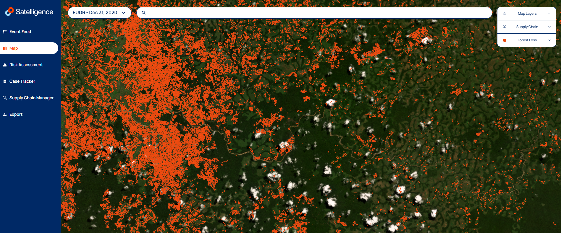
After receiving geolocation data from suppliers, we verify that no deforestation happened on or near the reported plots. To do this, we use Satelligence, a satellite monitoring platform.
Satelligence combines high-resolution satellite images with machine learning to detect land cover changes and tree loss. When we upload GPS coordinates, the platform flags any deforestation occurring after December 31, 2020 – the EUDR cutoff date.
This technology helps us validate supplier data, spot risk hotspots, and act when necessary. If Satelligence flags an issue, we engage with the supplier to understand and resolve it collaboratively. Satelligence also tracks long-term trends, giving us a deeper understanding of the landscapes we source from.
This satellite validation adds a vital layer of assurance to our due diligence. It supports EUDR compliance and strengthens our broader sustainability goals.
A Collaborative Path Forward
Building traceable, deforestation-free supply chains is not a task we can accomplish alone. It requires partnership, openness, and a willingness to evolve together. We know that some suppliers may face challenges – especially in remote areas or where formal land mapping is limited. That’s why we approach this work with patience, flexibility, and a strong belief in collaboration.
Our process is unfolding step by step. We start by mapping the data that already exists. Then we identify where information is missing. Together with our suppliers, we work to close those gap – collecting, verifying, and refining the data until we have a complete, accurate picture. Along the way, we’re learning more about the realities on the ground, and how we can support each other in building supply chains that are not only compliant but also resilient, inclusive, and future-ready.
Share this article
Follow us
Latest articles
January 29, 2026
January 29, 2026